Home » New data offers homebuyers details about wildfire risk
New data offers homebuyers details about wildfire risk

June 10, 2022
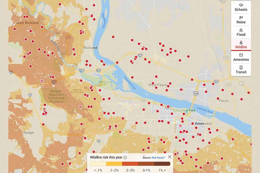
Most homes listed for sale in Benton County are at “major risk” for wildfires.
That’s according to a new metric on Realtor.com that allows homebuyers to assess a home’s wildfire risk, along with nearby home values, noise levels from traffic or airports, and the usual amenities like whether the property has a pool, or enough bedrooms for the kids and an office.
The New York-based First Street Foundation’s wildfire model provides the analysis of the risk individual properties face from damaging wildfires today, and up to 30 years in the future – the life of a typical home mortgage.
In Benton County, 95% of all homes (56,698 out of 59,468 homes) are at major risk of being impacted by wildfire over the next 30 years, according to the foundation’s data. About 89% of Franklin County homes (20,465 out of 23,098 homes) are at moderate risk.
Matthew Eby, founder and executive director of the nonprofit foundation, said the risk information “will prove critical in ensuring everyone has the insights they need to understand their personal risk to avoid and protect against the devastating impact of a wildfire.”
According to a recent Realtor.com survey, seven out of 10 recent homebuyers considered the risk of natural disasters when deciding where to live, according to Sara Brinton, lead product manager at Realtor.com.
“Wildfire risk information empowers consumers to protect their homes against the increasing threat of wildfire damage,” she said in a news release.
Vicki Monteagudo, designated broker with Century 21 Tri-Cities in Richland, said she’s a proponent for putting all the cards on the table when it comes to buying homes.
She said potential homebuyers aren’t asking about wildfire risk when looking at Tri-City properties.
“We hear it more in Kittitas County. I think most people associate wildfires with large trees,” she said.
She also said to put the risk data into perspective. “What we’re looking at in the Tri-Cities lights up for just a 1% risk,” she said.
Lonnie Click, fire chief with Benton Fire District 1, wasn’t convinced the data was completely accurate. As he clicked through the maps and property listings on Realtor.com, he questioned why some places in his fire district were listed at a higher risk than their neighbors.
“That doesn’t make any sense. Do they have a pool or what?” he said. “It’s very broad computer modeling, which is not real life.”
His fire district covers 320 square miles of southeast Benton County, including the communities of Finley, south Kennewick, El Rancho Reata and Badger Canyon.
“In the Tri-Cities, I don’t how beneficial it is. They need to look at the property they’re buying, what the adjacent property looks like, what kind of fuels there are – has it been taken care of, is there a defensible space, a green belt, around the residence? Is there shrubbery around the house and near the soffit and eaves? That’s what they need to look at,” Click said.
He agreed there are “hot areas in the Tri-Cities,” but recommended checking with local fire officials instead of relying on the risk map since they know the area and terrain better.
The First Street Foundation’s fire model used information about fuels, weather, historical wildfires and other measures to estimate properties’ risks.
Packaged for the average consumer, the new risk projections come as fire season begins to ramp up.
Most wildland fires in the Tri-City area are fueled by grass.
“In an event that there’s ignition, then based on fire weather for that given day or period, that will determine what the risk is,” Click said.
The fire chief is already concerned about July and August fires because of this year’s cool, wet spring.
“Every time it rains, we get another dose of Mother Nature’s irrigation, allowing everything to grow,” he said. This means when the hot weather marches in this summer, everything dries out, creating lots of fuel for fire.
Roadside starts — a mechanical failure, tire blowouts, metal hitting the ground — cause sparks and are a significant cause for wildland fires. “We don’t even need lightning,” he said.
Human causes closer to home also can trigger a blaze. Embers from backyard fire pits can float onto pine needles, arborvitae or grass clippings. “Then we’re off to the races,” Click said.
Steve Lambert, designated broker/owner of Tri-Cities Life Real Estate in Kennewick, said Realtor.com’s new metrics were fascinating to look at but he wasn’t sure potential home sales would be affected by properties labeled at a higher risk.
If anything, the additional information might give potential buyers a heads up about higher insurance premiums, he said.
The information, like flood risk data, also may prompt buyers to ask more questions and guide a potential offer, Lambert said.
He also noted that taking a holistic approach to buying or selling your home is a good idea.
“Even if you’re not looking to sell your house, it’s good to know what your house is worth,” Lambert said. He said this can help guide conversations about home insurance coverage and recommends reevaluating your home once a year.
The new wildfire data shows Washington has $134.9 billion in single-family home values at risk, ranking 10th in the nation.
Statewide, 480,800 properties have at least 0.03% likelihood of being in a wildfire this year (1% over 30 years). This represents about 16% of all properties. Of those, 110,100 properties have at least 0.2% risk (6% over 30 years), or 3.6% of all properties, according to the data.
The state of Washington has had 517 recorded historic wildfires larger than 1,000 acres between 1984 and 2020, which has resulted in more than 6.4 million cumulative acres burned across the state over this time period, according to the foundation’s fire modeling. Some 32,700 properties in the state were identified as being within the boundaries of these wildfires, with another 1 million properties within 20 miles.
Since 1984, the foundation’s report listed 36 wildfires recorded near Benton County and 15 near Franklin County.
For more information
To learn about your property’s wildfire risk, go to: riskfactor.com.
For tips on how to safeguard your property, go to: bces.wa.gov/resources/fire-safety-information.
Real Estate & Construction Local News
KEYWORDS june 2022


