Home » Richland braces for Bateman causeway removal
Richland braces for Bateman causeway removal

February 10, 2023
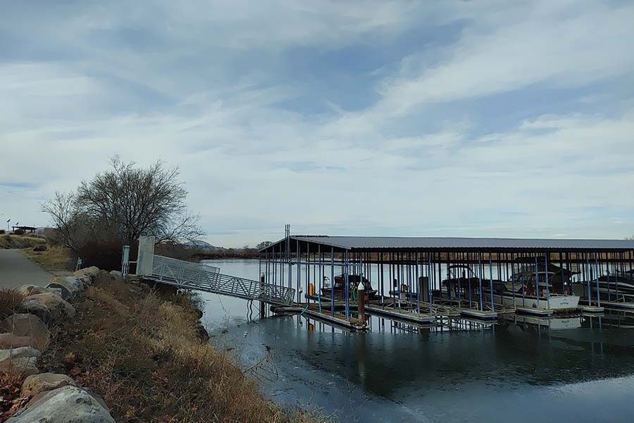
Richland is bracing for the impact of what removing the Bateman Island causeway will have on the Yakima River Delta and on the Columbia Park Marina and public boat launch.
The U.S. Army Corps of Engineers is finalizing a $13.9 million plan to fully remove the illegally-built land bridge, which is blamed for the warm, brackish conditions that threaten endangered salmon, steelhead and other species at the confluence of the Columbia and Yakima rivers.
Once the causeway is removed, water will flow at a rate as high as three feet per second around the south end of Bateman Island in the spring, according to the city of Richland. That is too strong for the private marina and public boat launch, which are currently shielded by the dirt structure.
The corps cites a far lower figure for the remaining 90% of the time, saying the water flow will be marginal and will have little impact on the marina.
The corps released a draft Finding of No Significant Impact for the plan on Jan. 26 and is accepting public comment through March 10.
Removing the causeway will support salmon habitat. Leaving it will undermine hundreds of millions of dollars being invested to establish fish passage in Cle Elum, remove a dam in Yakima and other projects along the length of the Yakima River, the Army corps said.
Richland, which has monitored plans to remove the causeway for more than five years, is preparing to hire experts in marine law and engineering to represent its interests. That includes protecting the privately-owned Columbia Park Marina and the city-owned public boat launch, heavily used by fishers, kayakers, standup paddleboarders and other boaters.
Joe Schiessl, deputy city manager and longtime point person on the causeway issue, said Richland embraces the goal of clean water at the delta, but must consider what will happen once the causeway is gone, and water again flows around both sides of Bateman Island.
The marina was not designed for swift currents. Boaters would avoid trying to maneuver around docks in such conditions.
Schiessl briefed the city council about the plan in January, shortly before the corps advertised it to the public.
“These docks are not engineered or built to operate in a river environment,” he said. “If the United States is proposing a project that renders a marina inoperable, that’s an impact, a negative downstream impact, that shall be mitigated.”
Mayor Terry Christensen agreed the city needs to support a business threatened by a major change to how water moves through the heart of the Tri-Cities.
“I want to protect the business,” he said during the January meeting.
The causeway was constructed apparently without permission in the mid-1940s by a farmer on Bateman Island. The 500-foot structure rests on 37,000 cubic yards of dirt and rocks.
Today, it is considered an illegal encroachment on the riverbed, which is owned by the state of Washington.
Its impact on how the Yakima River drains into the Columbia at the Richland Wye is obvious from aerial photos.
The causeway, which has no culverts, partly dams the Yakima River, forcing water to flow upstream and around Bateman to the north before it merges with the waters of the Columbia. The Delta is brown, brackish and silty. The Columbia is a ribbon of deep blue.
The causeway exists in a legal gray area. Hikers and birdwatchers use it to visit Bateman. So do fire trucks. Richland, which controls the island under a 50-year recreation lease with the corps, dispatches wildland fire crews to battle fires that break out roughly once every five years.
Schiessl said a dispute over firefighting strategies between the city and the Department of Natural Resources once delayed trucks by two to three minutes. Schiessl said the city prevailed when it pointed out people camped on the island, putting lives at stake.
At the time, aerial tankers assigned to Eastern Washington were out of service for maintenance. Pasco’s fire boat has a 100- to 150-foot limit, giving it the ability to sprinkle the island’s edges.
The lost minutes counted, he said.
There is no plan to replace the causeway with a bridge, a major sticking point for island users and the city.
But in the long term, Bateman Island may not remain in public ownership. The Confederated Tribes of the Umatilla Indian Reservation or the Yakama Tribe could pursue ownership if – or when– Congress considers transferring portions of the Tri-City waterfront back to local control.
But removing the causeway will allow water to flow around both sides of the island. It will flush out algae, sediment and restore water temperatures that sustain cold-water species that must migrate through the Delta as juvenile smolts and as adults. The warm water is a haven for nonnative species such as small mouth bass and channel catfish, which feed voraciously on young salmon.
Smolts that reach the delta are highly vulnerable and are “essentially waiting to be eaten or to die of (high) temperatures,” one corps official said.
The restored conditions will be good for native fish, but not the marina and public boat launch.
Schiessl said if the government takes steps to harm a city facility, it has a responsibility to mitigate it.
The situation raises a tantalizing prospect: Developing a protected marina on the south side of the delta that replicates the Columbia Park Marina, which is on the north. Under the right conditions, Columbia Park Marina could be moved to a niche further downstream.
That is not as far-fetched as it sounds.
The “niche” marina was proposed in a 1970s plan, before Richland annexed the Wye and Benton County was responsible for the area. Schiessl said several complicated and expensive steps would have to occur for a “second Columbia Point Marina,” but it is possible.
He added that the odds of success would be very low.
The marina is operated by longtime Tri-Citians Amy and Greg Ford under a month-to-month lease. It offers 104 slips as well as guest dock privileges. Its lease expired in 2017 and the corps refused to renew it, according to corps documents. The Fords could not be reached for comment.
The causeway predates construction of McNary Dam and 17 miles of federal levees along the Tri-City waterfront in the 1950s. Together, they delivered a devastating blow to migrating salmon, both adult and juvenile.
According to the corps, 82% of riparian and shallow water habitat supporting salmon, birds, wildlife and other threatened aquatic species was destroyed. Lake Wallula, the pool formed behind McNary Dam, inundated the lower two miles of the Yakima River.
The corps estimates salmon runs once saw half a million fish pass through the Yakima River Delta. In the modern era of dams and agriculture, that has dwindled to about 10,000.
The Yakima Delta water project is a Washington Department of Fish and Wildlife initiative with the corps.
“These effects from the removal of the causeway will significantly increase the success of migrating salmon species,” the corps said.
Cooperating agencies include the U.S. Fish and Wildlife Service, Washington Department of Ecology, the National Marine Fisheries Service, the Confederated Tribes of the Umatilla Indian Reservation and the Confederated Bands and Tribes of the Yakama Nation.
The Yakama Tribe supports removing the causeway and relocating the marina.
Learn more about the corps’ plan and submit comments at bit.ly/YakimaRiverDelta.
Public comments and open house
The Army Corps invites public comments on the Yakima River Delta ecosystem restoration project.
An open house is from noon to 2 p.m. Feb. 23 and from 3-6 p.m. at the Reach Museum, 1943 Columbia Park Trail, Richland.
Written comments may be emailed to: NEPANWW@usace.army.mil with “Yakima River Delta” in the subject line.
The 30-day comment period ends March 10.
Real Estate & Construction Local News
KEYWORDS february 2023


